|
This ancient village was once known as Huehuetlapayán, Hueytlató, or Primitiva Tula. In the second half of the 11th Century,
it was incorporated into the kingdom of Payaquí, founded by the ancient and venerable Topilzín Aexitl, and as of that period,
produced a strong interbreeding between the native Maya–Chortis peoples and the emigrating Toltecs. This interbreeding
was such that at the dawn of the 16th Century, the inhabitants of Citalá spoke neither the Chorti nor Nauta dialects, but
rather a single language: Alagüilak.
The ancient Maya–Chortis people called the village “Kujkaijá,” and upon translating the name into Náhuat,
the Toltecs changed it to “Citalá.” The name “Kujkaijá” means “River of Stars,” derived
from a combination of the words “Kujkai” or “Kujk’ai,” for “star” or “bright
star,” and “ja” for “water” or “river.” The name “Citalá” also means
“River of Stars,” with the word “Cital” signifying “star,” and the vowel “a”
meaning “water” or “river.”
In the political order established by the Spanish, Citalá was a feudal village of Gales, the supreme chief of Copán. The region
was conquered and brought into the Spanish royal domain by the conquistadors Hernando de Chávez and Pedro Amalín, who triumphed
in their assault on the city of Copán after a prolonged siege and many bloody battles.
King Gales fled the massacre in Copán and established his barracks in the fortified city of Citalá. Here he and his soldiers
mounted a heroic, but ultimately doomed, resistance to the fair-haired invaders from overseas.
These wars of conquest reduced the population considerably. By the year 1550, the ancient grand metropolis of the Maya–Chorti
had scarcely more than 800 inhabitants.
According to the first mayor of San Salvador, Manuel de Gálvez Corral, in 1740 the town of Citalá (then referred to as San
Francisco Citalá) counted merely 22 tax-paying Indians or heads of family, that is to say, a population of only 110 people.
The town subsisted “through fruits, corn, chickens, honey from beehives, and LOREA.”
In 1770 the archbishop Pedro Cortés y Larraz relates that the town of Citalá was annexed to the curate of the village of Tejutla,
and that its total indigenous population was represented by 167 people distributed among 27 families.
In reference to these Indians, his wife declared them “docile and attentive,” and “well mannered.”
“They are, in sum, of all those we have encountered up until now, the most well raised, and all of us have taken great
pleasure in having seen and had dealings with them.”
Partition of Tejutla in 1786
The quartermaster Antonio Gutiérrez and Ulloa reported that in 1807, his principal harvest was of sugar, and that he was situated
in the royal road for Comayagua (Honduras). From 1824 (June 12) to 1833 (May 13), Citalá belonged to the department of San
Salvador; from 1833 (October 21) to 1835 (May 22) to the department of San Salvador; from 1835 (May 22) to 1855 (February
14) to the department of Cuscatlán; and as of the latter date to the department of Chalatenango.
By 1890, its population had risen to 1,850 inhabitants. Documents from 1890 refer to Citalá as simply a village, but one
document dated October 1892 refers to it as having the rank of town, a rank gained during the administration of General Carlos
Ezeta.
From February 19, 1854, to March 1846, Citalá was included in the jurisdiction of the Metapán valley of Montenegro, and was
definitively separated in the latter date. Under a law passed on April 29, 1925, the municipality of Citalá was legally separated,
while the city of Metapán incorporated the outlying districts of Camulián and Las Pavas.
|
 |
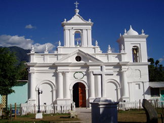 The Catholic Church
The church was built in the year 1892 (or in this year, the estate in which the church is located was acquired). The church
used to belong to the jurisdiction of La Palma. In actual practice it has been administered by the Franciscan mothers. Until
the year 1997, it was looked after by the presbyter Ildefonso Mejía, and from the same year onward, by the presbyter Rodin
Ramírez. Alongside the southeast, visible from the end, is the tallest elevation in the country, that is, the peak of El Pital.
Its owner is the Catholic Church of El Salvador. From November 30 to December 8 are the patron saint festivals in honor of
the Immaculate Virgin Conception of Mary. Since its beginning it has been used for religious purposes.
Central Park
Based on town plants drawn up by the Spaniards, which began with the grand plaza, in whose surroundings was located the church,
the town hall, and the houses of the first inhabitants, one can assert that in the beginning of the 20th Century, these plazas
began to be transformed into parks, that is, with their spatial dimensions and uses transformed. In this park, located in
front of the principal entrance of the parochial church, is located a cross dating from the year 1982. Furthermore, there
are three trees DE AMATE that provide shade for residents and visitors. The church and the park have as their visual end point
the tallest elevation in El Salvador, that is, the peak of El Pital.
Principal Historic Dates
|
1804
|
Church of San Francisco Citalá is constructed. But the façade of the altar was remodeled in 1892. (The church leaders were
Tiburcio Portillo and Simon Sarmientos.)
|
|
1817
|
Parochial convent is constructed with the help of Archbishop Pérez Aguilar.
|
|
1872
|
Municipal office is founded.
|
|
1925
|
Salvador Mendieta Middle School begins operations, with 1st and 2nd grade classes offered and two teachers.
|
|
1956–62
|
The Actual School is constructed. Before construction of the hammock bridge, people crossed the river in big PEROLES with
the help of swimmers, but also owing to the water of the river, which flowed gently. Later a carpenter constructed a CAYUCO,
but it did not work, and upon placing it in the water it sank. Until 1945 construction of the hammock bridge continued.
|
|
1960
|
Club of Monte Cristo is founded.
|
|
1967–68
|
Customs office is constructed.
|
|
1973
|
Kindergarden of Citalá is founded under the charge of professor Argentina Carballo.
|
|
1978
|
Health clinic is established through donations from the municipal office.
|
|
1983
|
National Institute of Citalá is founded.
|
|
1986
|
Bridge is constructed under the watch of President Ing. José Napoleón Duarte.
|
|
1990
|
Building of cobblestone roads begins in Citalá.
|
|
2007
|
The municipal office launches the official website of Citalá, a cornerstone of a new era of modern administration.
|
|
|
|
|
|
|
|
|